Summit County Boundaries
April 08, 2022 | Category: Breckenridge History
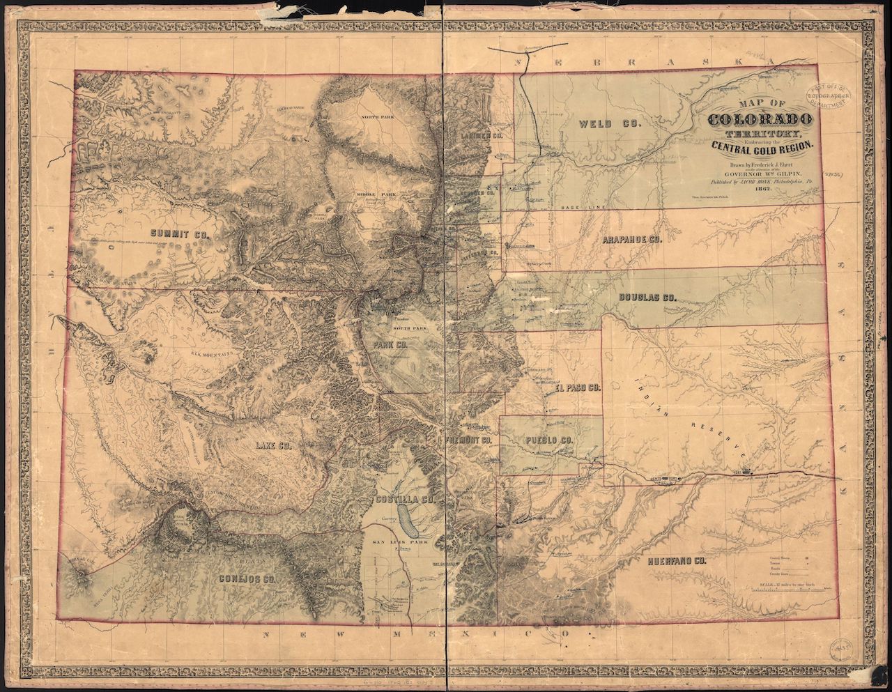 Prior to the creation of Colorado Territory, the land that became Colorado was divided among the territories of Kansas, Nebraska, New Mexico and Utah. Land west of the Continental Divide, including what became Summit County, belonged to Utah Territory. Colorado’s First Legislative Assembly approved legislation entitled ”An act to define county boundaries and to locate county seats in Colorado Territory,” on November 1, 1861. The act established the boundaries of Summit County as the Continental Divide on the east, Lake County on the south and, on the north and west, the territorial boundaries. Thus the original Summit County in 1861 included about one-sixth of Colorado Territory.
Since then seven counties have been formed from the original and what is now Summit County became the smallest of the seven.
In 1874, the legislature divided Summit County into Summit and Grand counties. In 1877, Summit County’s boundaries remained the same while the Legislature divided Grand County into Grand and Routt counties. In 1883, Routt and Grand counties remained the same but the Legislature cut Garfield and Eagle counties from Summit County giving Summit its present boundaries. In 1899, the Legislature divided Garfield County into Garfield and Rio Blanco counties. In 1911, Routt was divided and Moffet County created. Hence the original Summit County became seven counties: Moffat Routt, Grand, Rio Blanco, Garfield, Eagle and Summit.
The legislature chose Park City, near the mouth of Georgia Gulch, as the first county seat. The “city” of an estimated several thousand, enjoyed the honor until January, 1862 when the county commissioners decided to move the county seat to Breckenridge. The move occurred gradually. County minutes note that the commissioners met in both Parkville and Breckenridge from April, 1862 until June, 1864. After that, the commissioners met in Breckenridge.
The location of the county seat became a question again in 1882 as both Dillon and Frisco attempted to take the designation away from Breckenridge. Based on its geographic location at the center of the county and the coming of both railroads, some Frisco residents felt that their town should be the county seat. Frisco’s location placed it near the mines of the Ten Mile and Upper Ten Mile.
Breckenridge countered, noting the town’s location near the center of the county’s population, its size and the fact that the town already had the county buildings. It had excellent accommodations for those doing business with county courts and offices and qualified people to serve on juries. Moving the county offices would require the unnecessary construction of new buildings. When Dillon promised to erect the necessary county buildings at a cost of less than $800, Breckenridge reminded Dillon it had no railroad yet; the railroad could always change its plans.
Dillon received 1011 votes; Breckenridge 832; and Frisco, 285. Because Dillon did not receive the required two-thirds vote necessary for the move to occur, Breckenridge retained the county offices. The editor of the Montezuma Millrun predicted the demise of Breckenridge after the election; “the county seat would be lost in four years and real estate values would drop. No one would settle in Breckenridge and those remaining would wish that they had let the county seat go.”
written by Sandra F. Mather, PhD