B&B Trailhead to Reiling Dredge
Note: Before hitting the trails, read Preston’s Tips to make sure you’re ready for hiking in the High Country.
B&B Trailhead to Reiling Dredge
Difficulty: Green (easy) from B&B Trailhead to Reiling Dredge, returning on the road; Blue (moderate) returning via Minnie Mine Trail
Duration: 60-80 minutes from B&B Trailhead to Reiling Dredge, returning on the road; 2-2.5 hours total returning via Minnie Mine Trail
Distance: 2 miles from B&B Trailhead to Reiling Dredge, returning on the road; 2.9 miles total returning via Minnie Mine Trail
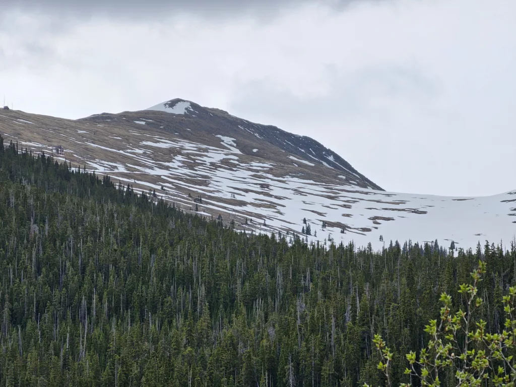
This first hike of the 2025 Hiking Season takes us to one of my favorite hiking locations in Breckenridge: French Gulch.
We’ll revisit French Gulch throughout this summer and into the fall when September’s changing leaves light up the north side of the gulch. Prepare for fabulous photographs around the Wellington ore bin with blue skies, white clouds, green pines and spruces, yellow leaves, and so on.
French Gulch is part of Breckenridge’s famed Golden Horseshoe which is estimated to have produced as much as 1,000,000 ounces of gold between 1859 and 1942, including Tom’s Baby, a 13.5-pound nugget of crystalline gold discovered in 1887. Specimens from the Golden Horseshoe were featured in the 1893 World’s Fair.
Gold mining falls into 2 general categories: lode mining (where miners blast into a mountainside to extract ore from the gold vein directly) and placer mining (where miners sift through rocks and soil to extract small pieces of gold that have been eroded off a gold vein (the “mother lode”) up on a mountainside and brought downhill through the action of water and gravity. The first half of this hike focuses on placer mining where panning, rocker boxes, and Long Toms gave way to massive gold dredges that ground their way up and down the valleys in and near Breckenridge.
At the halfway point of this hike, you’ll have an option to take the quick and easy way back via French Gulch Road or to loop back to the parking lot after hiking up to a number of mine sites where millions were made lode mining.
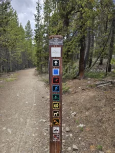
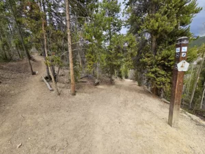
Trails in the Breckenridge area are well marked by trail posts, but from time to time you’ll want to consult your map on a hiking app to make sure you’re heading where you want to go. For those who’d like a guided hike with running commentary, stories, and insights, Breck History offers Hike the Golden Horseshoe which follows the first half of this trail (from the B&B Trailhead to the Reiling Dredge).
This hike begins at the B&B Trailhead. The Boston and Breckenridge (B&B) Mining Company was formed in 1940 and procured many of the area’s historic mines which operated until 1942 when the War Production Board issued Order L-208 which effectively shuttered gold mining in order to free up men and materials for use in World War II.
The B&B Trailhead has a large parking area suitable for about 2 dozen vehicles. Start your hike at the east end of the parking area where you’ll find a large trail map, a Muddy Meter, and signpost. A few steps away you’ll see an original Keystone Drill. The Keystone Drill allowed miners to test the sediment at varying depths within the soil to ensure they were making informed choices about where to exert their efforts.
Our first decision is whether to take the B&B Spur or go back to the main B&B Trail. The Spur trail is a little shorter but isn’t as obvious, so if you’re not confident in your ability to spot and follow an unmarked trail, your best bet is to follow the B&B Trail to the other end of the B&B Spur trail.
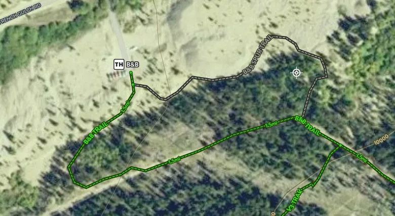
But if you are feeling adventurous, the B&B Spur takes you around the right side of the large dredge pile, up some stone stairs, and up to a flat surface on top of the dredge piles where you’ll get a great view of the Wellington Ore Bin. (more to follow on the Wellington later this hiking season).
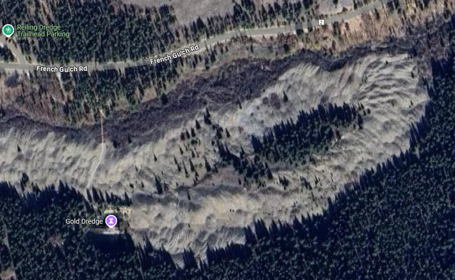
The small target icon in the screen capture denotes where there’s a Depression Era mining site display. During the depression families came to Breckenridge in search of gold. By the late 1930s the easily reached placer deposits had already been hit hard, but small amounts of gold could be found and put a bit of food on the table.
From here, head to the main B&B Trail and turn left. Stay on the B&B trail, staying left at both the V3 and Turks Trail turnoffs.
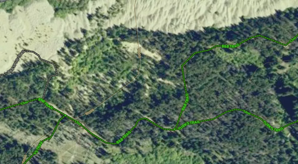
Staying left at the Turk’s Trail split, the B&B Trail heads north to parallel the Dredge Piles. Don’t get too close to the edge, but if you go out toward the dredge piles you’ll get a good idea what the dredge boats could do.
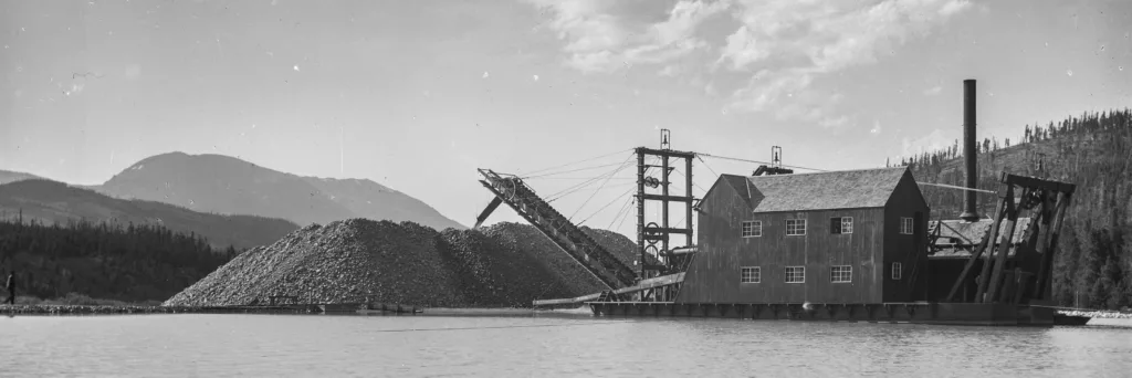
A dredge boat is a floating gold extraction machine that used a line of heavy steel buckets to dig down to bedrock and pull up all the dirt, rocks, and gold for processing. Large rocks were immediately rejected by grizzly bars with the smaller rocks run through a rotating trommel where water would wash the dirt off the rocks. The rocks would be sent out the back of the dredge boat (making the piles you see before you) while the dirt and gold would be sent through a sluice box where riffles would create spots for the heavy gold to deposit out of the flow of muddy water. The water would then be dumped overboard to settle and the gold would periodically be collected from the sluices.
In gold mining, the name of the game is volume and efficiency. Breckenridge went through a number of boom-and-bust phases as the easiest gold was extracted while the harder to process gold was left behind. A technical innovation would occur that then made extraction of the remaining gold economically viable and another boom would start. Gold Dredging and Hydraulic Mining were the pinnacles of placer mining in the early 1900s but had a massive effect on the environment. The land started with rocks below and soil on top, but the dredging process inverted the landscape, putting the soil below and the rocks on top, leaving the miles of dredge piles that you see.
Rendering of a deadman anchor.
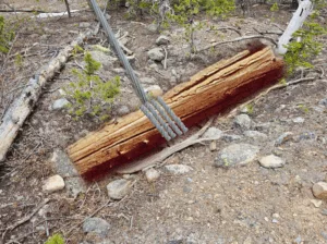
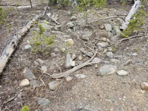 While hiking in Breckenridge, keep your eyes open and you’ll see evidence of mining everywhere. Level trails crossing the sides of the mountains are typically water collection ditches that intercepted water heading downhill and providing it to mining operations throughout the area. On the B&B trail, you’ll frequently see evidence of mining to include deadman anchors for the dredge boats.
Dredge boats are called boats in that they floated, but they had no steering or propulsion. The deadman anchors you can see on the side of the trail were spots where the miners would dig a trench that they’d put a log wrapped in steel cable into. The cable would then run to winches on the dredge.
Mary M. Marks Photograph Collection, 1890-1910; Utah State University Library. Courtesy Breckenridge History.
Picture a dredge boat at the right end of its arc. At the back left of the boat a long post called a spud would be dropped down to anchor the boat and serve as a pivot point. Onboard, winches would pull the front of the boat to the left and the bucket line would be lowered to dig out the ground as deep as the boat could reach or until they hit bedrock. Then the bucket line would be lifted and the boat would pivot more to the left. Once their arc was completed, the right spud would be dropped, the left spud raised, and the boat would slowly be winched to the right, thus advancing in the overall direction of travel. The picture below shows how the Reiling Dredge worked it way up the floor of French Gulch before turning around.
Continuing East on the B&B trail, you’ll next come to an exhibit about an Exploration or Coyote Shaft. Be sure to keep a hand on kids or dogs because an fall into the metal, wood, rock, and debris of the shaft will NOT be pleasant.
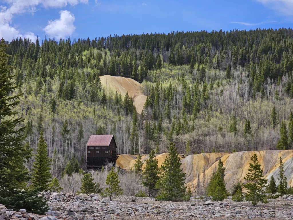
A bit further along the trail you’ll reach the highlight of the first half of this hike: The Reiling Dredge. This dredge operated from 1908 to 1922, ultimately
sinking and being abandoned on Nov. 18, 1922. After nearly 100 years in its pond, the dredge was stabilized in 2018 (to put this timeline into historical context, the first bedrock stair leading to Tut’s Tomb was discovered on Nov. 4, 1922, and the tomb was breached on Nov. 26).


")

")
Continuing downhill we now cross the dredge piles. Cross the river and make a short climb up to French Gulch road and the Reiling Dredge Trailhead.
At this point you need to decide whether to head back to the B&B Trailhead via French Gulch Road (3/4 mile) or continue upward to visit some lode mining sites.
If you’d like to see a mine site without making the hike up to the Minnie Mine, the Lucky Mine Concentration Mill is very close to the Reiling Dredge Trailhead and has examples of trommels and concentration jigs. Just go 40 feet past the trail marker and turn right to go uphill a short distance on an easy-to-miss trail. The Lucky Mine’s concentration mill was located here, right below the Lucky Mine above to concentrate the ore prior to sending it off for smelting. Ore would be crushed, run through trommels to remove gold and dirt from rocks and then agitated in the well-preserved concentration jigs.
When done at the Lucky, return to the Minnie Mine trail and turn right to head uphill. There is a trail marker where the X10U8 Trail splits to the left and the Minnie Mine trail continues up to the right. The X10U8 Trail will take you past the Rose of Breckenridge mine enroute back to the B&B Trailhead if you want to trim some distance and vertical rise off your hike.
For those continuing up the Minnie Mine trail, after just a few more minutes of hiking you’ll be at the Minnie Mine and Traylor Shaft Site. Along the way you’ll get good views of French Gulch and the Breckenridge Ski Area. Sharp eyed hikers might even spot the Carbonate Mine and Aerial Tramway up on Bald Mountain.
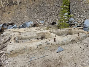
While the collapsed debris from the Minnie Mine concentration mill and machine shop may look like an unrecognizable junk pile, careful observation will reveal that the site’s boiler was off to the right side (east) of the building and converted steam power into rotational motion that drove an axle that powered devices throughout the building by transferring power from the axle to the machinery using large belts.
When done here, continue hiking west. After going uphill a short way, you’ll hit the high point of this hike and start your way down. Along the way you’ll see the B&B Trailhead parking lot about 300′ below as well as the Country Boy Mine. There’s also an interpretive sign at the turnoff for the Truax Mine but the information sign at the Truax has not been replaced yet.
A little while farther is a switchback where the Minnie Mine trail continues downhill to the left. A short distance down this trail you’ll come across the X10U8 trail. A short distance to the left on this trail will take you to the Rose of Breckenridge mine. Then return to this spot and continue down the X10U8 trail to the end, across the road from where you started. Your final point of interest is the Wellington Ore Bin, a structure that was stabilized in 2016 by Breckenridge History. We’ll revisit the Wellington Ore Bin in September when the leaves are changing, but this 5-story structure was used to receive and sort high grade ore from low grade ore.
I hope you enjoy your outing. If you see me out on the trails, please stop me and say hi!
Preston